
Your summer trails trip-planning guide
The weather is warming up, the sun is shining, the birds are chirping–you know what that means! Time to hit the trails!
We want you to be prepped and ready for any and all trips this summer. Here’s our guide of PTNY’s top navigation, transportation, and recreation tips for traveling along the Erie Canalway Trail.
Transportation
Yes, the Erie Canalway Trail is 360 miles straight across the state–but once you finish the trail you’ll need a way to get back home. There are a few options for getting to and from the trail, including by shuttle, train, or car. Read our transportation guide for more details, including specific locations and services.
There are a number of shuttle companies across the state that provide transportation for cyclists of the Erie Canalway Trail. Please note that there are currently no luggage transport services being offered along the Erie Canalway Trail corridor.
Thanks to our years of dedicated advocacy, Amtrak is now equipped to accommodate bicycles on trains across New York. The Maple Leaf, Empire Service, and the long-distance Lake Shore Limited lines run between Albany and Buffalo.
Another option is one-way car rentals to get you and your bike to or from the trail. If you choose to drive a personal car, there are also long term parking options available at local train stations.
Navigation
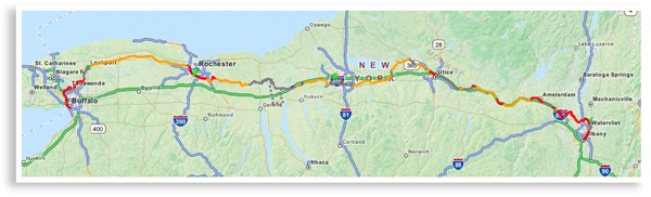
Here at PTNY, we LOVE maps. They guide our journeys and help track our progress. That’s why we created an interactive map of the Erie Canalway Trail.
The map helps riders navigate to different destinations on the trail, showing surface types and up-to-date routing, including any detours. The map also informs riders of trail closures, safety tips, accommodations and attractions along the greenway. Measure mileage from point to point using GPS to quickly display your location.
Prefer a hard copy? Check out Cycling the Erie Canal: A Guide to 360 Miles of Adventure and History Along the Erie Canalway Trail. The 142-page guidebook includes 38 easy-to-read, full color maps, packed with detailed information about the trail itself and the many things to see and do along the way.
Trip Planning Resources
Riding along the Empire State Trail is about so much more than cycling. You can visit historic sites, scenic vistas and charming small towns with unique shops, museums, and restaurants. Plan your trip around local fairs and festivals for added excitement. With so many things to do, where do we begin?
Visit Cycle the Erie Canal for a detailed list of attractions grouped by both interest and region, with seasonal Canalway events listed by month. You’ll even find places to stay, Bike shops, and Bike Friendly New York certified businesses, which provide bike parking, trail knowledge and local cycling information. Feel like exploring off the beaten path? We’ve got your back! Utilize our connecting trail itineraries to explore even more!
Erie Canalway Trail Community
Looking for word of mouth recommendations and more expert tips? Join our group of cycling enthusiasts, who are happy to share. To join the conversation, follow the Erie Canalway Trail on Facebook and Instagram. Or, join our Facebook group to share your questions and get feedback from other riders.
You’ve organized transportation, utilized our interactive map, joined our Facebook group, and completed the trail–now what? Add your name to the list of official Erie Canalway Trail end-to-enders at www.ptny.org/end-to-end. We hope to see your name next!
